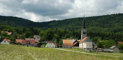
Babno Polje
Babno Polje | |
|---|---|
 Babno Polje in summer | |
| Coordinates: 45°38′40.19″N 14°32′52.88″E / 45.6444972°N 14.5480222°E | |
| Country | |
| Traditional region | Inner Carniola |
| Statistical region | Littoral–Inner Carniola |
| Municipality | Loška Dolina |
| Area | |
| • Total | 16.4 km2 (6.3 sq mi) |
| Elevation | 761 m (2,497 ft) |
| Population (2002) | |
| • Total | 317 |
| [1] | |
Babno Polje (pronounced [ˈbaːbnɔ ˈpoːljɛ]; in older sources also Babino Polje,[2] German: Babenfeld,[2] Italian: Babinapoglia[3][4]) is a village in the Municipality of Loška Dolina in the Inner Carniola region of Slovenia, on the border with Croatia.[5]
Name
[edit]Babno Polje was attested in historical sources as Pabenfeld in 1402 and Pobenueld in 1449.[6]
Church
[edit]The parish church in the settlement is dedicated to Saint Nicholas and belongs to the Ljubljana Archdiocese.[7] It was first mentioned in written documents dating to 1526.[8]
Climate
[edit]Statistically, Babno Polje is the coldest inhabited settlement in Slovenia.[9] It currently holds the record for the lowest officially verified temperature in Slovenia, of −34.5 °C (−30.1 °F), recorded on two separate occasions, 13 Jan 1968 and 15-16 Feb 1956.[10]
Babno Polje has a humid continental climate (Köppen Dfb).
| Climate data for Babno Polje (1991–2020 normals, extremes 1950–2020) | |||||||||||||
|---|---|---|---|---|---|---|---|---|---|---|---|---|---|
| Month | Jan | Feb | Mar | Apr | May | Jun | Jul | Aug | Sep | Oct | Nov | Dec | Year |
| Record high °C (°F) | 14.1 (57.4) |
17.9 (64.2) |
22.8 (73.0) |
25.6 (78.1) |
30.0 (86.0) |
34.1 (93.4) |
34.6 (94.3) |
35.2 (95.4) |
30.5 (86.9) |
24.4 (75.9) |
21.2 (70.2) |
15.5 (59.9) |
35.2 (95.4) |
| Mean daily maximum °C (°F) | 2.4 (36.3) |
4.3 (39.7) |
8.6 (47.5) |
13.3 (55.9) |
17.9 (64.2) |
22.1 (71.8) |
24.3 (75.7) |
24.3 (75.7) |
18.6 (65.5) |
13.5 (56.3) |
7.8 (46.0) |
2.8 (37.0) |
13.3 (55.9) |
| Daily mean °C (°F) | −2.4 (27.7) |
−1.7 (28.9) |
1.8 (35.2) |
6.3 (43.3) |
11.2 (52.2) |
15.3 (59.5) |
16.9 (62.4) |
16.3 (61.3) |
11.3 (52.3) |
7.4 (45.3) |
3.1 (37.6) |
−1.8 (28.8) |
7.0 (44.6) |
| Mean daily minimum °C (°F) | −6.9 (19.6) |
−7.0 (19.4) |
−3.6 (25.5) |
0.1 (32.2) |
4.4 (39.9) |
8.0 (46.4) |
9.4 (48.9) |
9.4 (48.9) |
5.9 (42.6) |
2.7 (36.9) |
−0.8 (30.6) |
−6.1 (21.0) |
1.3 (34.3) |
| Record low °C (°F) | −34.6 (−30.3) |
−34.4 (−29.9) |
−31.1 (−24.0) |
−19.1 (−2.4) |
−12.2 (10.0) |
−5.6 (21.9) |
−1.2 (29.8) |
−2.0 (28.4) |
−7.8 (18.0) |
−16.4 (2.5) |
−27.0 (−16.6) |
−29.7 (−21.5) |
−34.6 (−30.3) |
| Average precipitation mm (inches) | 101 (4.0) |
115 (4.5) |
107 (4.2) |
115 (4.5) |
124 (4.9) |
129 (5.1) |
106 (4.2) |
123 (4.8) |
173 (6.8) |
200 (7.9) |
209 (8.2) |
155 (6.1) |
1,656 (65.2) |
| Average extreme snow depth cm (inches) | 17 (6.7) |
24 (9.4) |
16 (6.3) |
1 (0.4) |
0 (0) |
0 (0) |
0 (0) |
0 (0) |
0 (0) |
0 (0) |
3 (1.2) |
10 (3.9) |
6 (2.4) |
| Average precipitation days (≥ 0.1 mm) | 9 | 8 | 10 | 12 | 14 | 14 | 14 | 13 | 12 | 11 | 12 | 10 | 140 |
| Average snowy days (≥ 0 cm) | 21.8 | 20.6 | 17.1 | 5.0 | 0.2 | 0.0 | 0.0 | 0.0 | 0.1 | 0.4 | 7.6 | 18.4 | 91.3 |
| Average relative humidity (%) (at 14:00) | 75.5 | 71.7 | 65.7 | 62.1 | 61.9 | 63.6 | 59.5 | 61.9 | 64.7 | 67.8 | 74.5 | 78.9 | 67.4 |
| Source: Slovenian Environment Agency (snow depth 1981–2010, humidity and snow days 1961–1990)[11][12][13] | |||||||||||||
References
[edit]- ^ Statistical Office of the Republic of Slovenia
- ^ a b Leksikon občin kraljestev in dežel zastopanih v državnem zboru, vol. 6: Kranjsko. 1906. Vienna: C. Kr. Dvorna in Državna Tiskarna, p. 130.
- ^ Ballarini, Amleto; Sobolevski, Mihael (2002). Le vittime di nazionalità italiana a Fiume e dintorni (1939–1947) / Zrtve talijanske nacionalnosti u Rijeci i okolici (1939.–1947.) (PDF). Rome: Ministero per i Beni Culturali e Ambientali. p. 26. ISBN 88-7125-239-X. Archived from the original (PDF) on August 27, 2021. Retrieved January 7, 2021.
- ^ Memorie della Società geografica italiana, vol. 15. Rome: Società geografica italiana. 1916. p. 158.
- ^ Loška Dolina municipal site
- ^ "Babno Polje". Slovenska historična topografija. ZRC SAZU Zgodovinski inštitut Milka Kosa. Retrieved February 6, 2021.
- ^ Družina RC Church in Slovenia Journal website
- ^ "Local cultural heritage on the Loška Dolina municipal site" (in Slovenian). Archived from the original on 2014-04-07. Retrieved 2009-02-27.
- ^ "Najhladnejši naseljeni kraj v Sloveniji Babno Polje - Kam.si".
- ^ "Slovenski vremenski rekordi" (PDF) (in Slovenian). Slovenian Environment Agency. p. 2. Archived from the original (PDF) on 4 March 2016. Retrieved 26 July 2022.
- ^ "Babno Polje Podnebne statistike 1950-2020" (in Slovenian). Slovenian Environmental Agency. Archived from the original on 9 October 2023. Retrieved 9 October 2023.
- ^ "Babno Polje Climate Normals 1981-2010" (PDF). Slovenian Environmental Agency. Archived from the original (PDF) on 9 October 2023. Retrieved 9 October 2023.
- ^ "Babno Polje referenčno obdobje: 1961-1990" (in Slovenian). Slovenian Environmental Agency. Archived from the original on 24 April 2012. Retrieved 9 October 2023.
External links
[edit] Media related to Babno Polje at Wikimedia Commons
- Babno Polje on Geopedia


